
Topografische Karte Chertsey
Klicken Sie auf die Karte, um die Höhe anzuzeigen.
Chertsey
Samuel Lewis devotes one of his longest entries to the small town in his 1848 topographical guide to England.
Über diese Karte
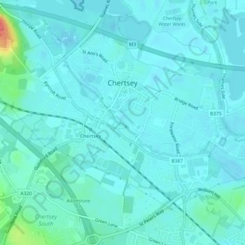
Name: Topografische Karte Chertsey, Höhe, Relief.
Durchschnittliche Höhe: 17 m
Minimale Höhe: 9 m
Maximale Höhe: 66 m
Andere topografische Karten
Klicken Sie auf eine Karte, um ihre Topografie, ihre Höhe und ihr Relief anzuzeigen.
Cooper's Hill Slopes
United Kingdom > England > Surrey > Borough of Runnymede > Englefield Green
Durchschnittliche Höhe: 38 m
Englefield Green
United Kingdom > England > Surrey > Borough of Runnymede
Durchschnittliche Höhe: 48 m
Chertsey
United Kingdom > England > Surrey > Borough of Runnymede
Samuel Lewis devotes one of his longest entries to the small town in his 1848 topographical guide to England.
Durchschnittliche Höhe: 22 m
Egham Wick
United Kingdom > England > Surrey > Borough of Runnymede > Englefield Green
Durchschnittliche Höhe: 55 m
Lyn Mushroom Farm
United Kingdom > England > Surrey > Borough of Runnymede > Lyne
Durchschnittliche Höhe: 39 m
Eastly End
United Kingdom > England > Surrey > Borough of Runnymede > Thorpe
Durchschnittliche Höhe: 17 m
Englefield Green
United Kingdom > England > Surrey > Borough of Runnymede
Durchschnittliche Höhe: 48 m
Chertsey
United Kingdom > England > Surrey > Borough of Runnymede
Samuel Lewis devotes one of his longest entries to the small town in his 1848 topographical guide to England.
Durchschnittliche Höhe: 22 m