
Topografische Karte Outremont
Klicken Sie auf die Karte, um die Höhe anzuzeigen.
Über diese Karte
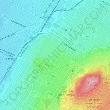
Name: Topografische Karte Outremont, Höhe, Relief.
Durchschnittliche Höhe: 94 m
Minimale Höhe: 53 m
Maximale Höhe: 215 m
Andere topografische Karten
Klicken Sie auf eine Karte, um ihre Topografie, ihre Höhe und ihr Relief anzuzeigen.
Rosemont–La Petite-Patrie
Canada > Québec > Agglomération de Montréal > Montréal
Durchschnittliche Höhe: 50 m
Mont-Royal
Canada > Québec > Agglomération de Montréal > Montréal
« Petite en altitude, la montagne est immense dans l’identité de la métropole avec son parc dessiné par Olmsted, ses belvédères qui nous font découvrir le fleuve oublié, ses cimetières reflétant la diversité montréalaise et ses grandes institutions qui la servent ». »
Durchschnittliche Höhe: 111 m
Pointe-aux-Trembles
Canada > Québec > Agglomération de Montréal > Montréal
Durchschnittliche Höhe: 14 m
Montréal-Nord
Canada > Québec > Agglomération de Montréal > Montréal
L'arrondissement de Montréal-Nord s'étend sur 11,07 km2. Son territoire forme une bande quasi-rectangulaire d'environ 5 kilomètres sur la rive montréalaise de la rivière des Prairies. Il s'étend sur le versant de la rivière, sur une pente douce de deux kilomètres, allant des berges jusqu'à environ 40…
Durchschnittliche Höhe: 31 m
Plateau Mont-Royal
Canada > Québec > Agglomération de Montréal > Montréal
Durchschnittliche Höhe: 70 m
Pierrefonds-Roxboro
Canada > Québec > Agglomération de Montréal > Montréal
Durchschnittliche Höhe: 30 m
Marc-Aurèle-Fortin
Canada > Québec > Agglomération de Montréal > Montréal
Durchschnittliche Höhe: 31 m
Colline de l'Abri
Canada > Québec > Agglomération de Montréal > Montréal
Durchschnittliche Höhe: 120 m
L'Île-Bizard–Sainte-Geneviève
Canada > Québec > Agglomération de Montréal > Montréal
Durchschnittliche Höhe: 32 m
Rivière des Prairies
Canada > Québec > Agglomération de Montréal > Montréal
Durchschnittliche Höhe: 36 m
Pointe-aux-Trembles
Canada > Québec > Agglomération de Montréal > Montréal
Durchschnittliche Höhe: 15 m
Parc Frédéric-Back
Canada > Québec > Agglomération de Montréal > Montréal
Durchschnittliche Höhe: 43 m
Île de la Visitation
Canada > Québec > Agglomération de Montréal > Montréal
Durchschnittliche Höhe: 30 m