
Topografische Karte Acworth
Interaktive Karte
Klicken Sie auf die Karte, um die Höhe anzuzeigen.
Über diese Karte
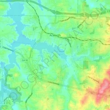
Name: Topografische Karte Acworth, Höhe, Relief.
Ort: Acworth, Cobb County, Georgia, United States (34.02738 -84.71971 34.07863 -84.63326)
Durchschnittliche Höhe: 281 m
Minimale Höhe: 252 m
Maximale Höhe: 348 m
Andere topografische Karten
Klicken Sie auf eine Karte, um ihre Topografie, ihre Höhe und ihr Relief anzuzeigen.
Marietta
United States > Georgia > Cobb County
Marietta, Cobb County, Georgia, United States
Durchschnittliche Höhe: 323 m
Aboretum
United States > Georgia > Cobb County
Aboretum, Cobb County, Georgia, United States
Durchschnittliche Höhe: 319 m
Kennesaw
United States > Georgia > Cobb County
Kennesaw, Cobb County, Georgia, United States
Durchschnittliche Höhe: 317 m
Marietta
United States > Georgia > Cobb County > Marietta
Marietta, Cobb County, Georgia, 30090, United States
Durchschnittliche Höhe: 302 m
Kennesaw
United States > Georgia > Cobb County > Kennesaw
Kennesaw, Cobb County, Georgia, 30144, United States
Durchschnittliche Höhe: 318 m
Powder Springs
United States > Georgia > Cobb County
Powder Springs, Cobb County, Georgia, United States
Durchschnittliche Höhe: 291 m
Vinings
United States > Georgia > Cobb County > Vinings
Vinings, Cobb County, Georgia, 30339, United States
Durchschnittliche Höhe: 281 m
Smyrna
United States > Georgia > Cobb County
Smyrna, Cobb County, Georgia, United States
Durchschnittliche Höhe: 289 m