
Topografische Karte Mililani Mauka
Interaktive Karte
Klicken Sie auf die Karte, um die Höhe anzuzeigen.
Über diese Karte
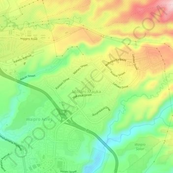
Name: Topografische Karte Mililani Mauka, Höhe, Relief.
Durchschnittliche Höhe: 254 m
Minimale Höhe: 141 m
Maximale Höhe: 398 m
Andere topografische Karten
Klicken Sie auf eine Karte, um ihre Topografie, ihre Höhe und ihr Relief anzuzeigen.
Waipio Acres
United States > Hawaii > Honolulu County > Mililani
Waipio Acres, Mililani, Honolulu County, Hawaii, United States
Durchschnittliche Höhe: 230 m
Schofield Barracks
United States > Hawaii > Honolulu County > Mililani
Schofield Barracks, Honolulu County, Hawaii, United States
Durchschnittliche Höhe: 279 m
Oʻahu Forest National Wildlife Refuge
United States > Hawaii > Honolulu County > Mililani
Oʻahu Forest National Wildlife Refuge, Mililani, Honolulu County, Hawaii, United States
Durchschnittliche Höhe: 456 m