
Topografische Karte Općina Konavle
Interaktive Karte
Klicken Sie auf die Karte, um die Höhe anzuzeigen.
Über diese Karte
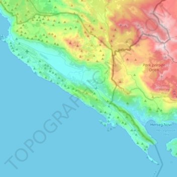
Name: Topografische Karte Općina Konavle, Höhe, Relief.
Ort: Općina Konavle, Dubrovnik-Neretva County, Croatia (42.39218 18.17394 42.61930 18.53380)
Durchschnittliche Höhe: 376 m
Minimale Höhe: -1 m
Maximale Höhe: 1.873 m
The Sniježnica peak at 1234 meters of altitude is the highest point of the Dubrovnik-Neretva County and village of Kuna with its 700 m altitude is the highest village in the county. Although Gruda is the administrative center of the municipality, the largest settlement is Cavtat.
Andere topografische Karten
Klicken Sie auf eine Karte, um ihre Topografie, ihre Höhe und ihr Relief anzuzeigen.
Rt Lumpar
Croatia > Dubrovnik-Neretva County > Dubrovnik
Rt Lumpar, Dubrovnik, Dubrovnik-Neretva County, Croatia
Durchschnittliche Höhe: 9 m
Ston
Croatia > Dubrovnik-Neretva County
Ston, Općina Ston, Dubrovnik-Neretva County, 20230, Croatia
Durchschnittliche Höhe: 74 m
Krst
Croatia > Dubrovnik-Neretva County > Dubrovnik
Krst, Dubrovnik, Dubrovnik-Neretva County, 20222, Croatia
Durchschnittliche Höhe: 258 m
The Dead Sea
Croatia > Dubrovnik-Neretva County > Dubrovnik
The Dead Sea, Dubrovnik, Dubrovnik-Neretva County, Croatia
Durchschnittliche Höhe: 6 m
Dubrovnik
Croatia > Dubrovnik-Neretva County > Dubrovnik
Dubrovnik, Dubrovnik-Neretva County, Croatia
Durchschnittliche Höhe: 65 m
Korčula
Croatia > Dubrovnik-Neretva County
Korčula, Dubrovnik-Neretva County, Croatia
Durchschnittliche Höhe: 44 m
Dubrovnik
Croatia > Dubrovnik-Neretva County
Dubrovnik, Dubrovnik-Neretva County, Croatia
Durchschnittliche Höhe: 295 m
Šibenik
Croatia > Dubrovnik-Neretva County > Duba
Šibenik, Duba, Općina Slivno, Dubrovnik-Neretva County, 20357, Croatia
Durchschnittliche Höhe: 88 m
Metković
Croatia > Dubrovnik-Neretva County > Metković
Metković, Grad Metković, Dubrovnik-Neretva County, 20350, Croatia
Durchschnittliche Höhe: 38 m
Desne
Croatia > Dubrovnik-Neretva County > Desne
Desne, Općina Kula Norinska, Dubrovnik-Neretva County, 20344, Croatia
Durchschnittliche Höhe: 178 m