Geolokalisieren
👉 Easily get elevation data in JSON, GeoTIFF and KML formats using Elevation API
Vielen Dank für die Unterstützung dieser Website ❤️
Spenden

Rüste dich für dein nächstes Abenteuer:

Als Amazon-Partner verdient diese Website an qualifizierten Käufen, ohne zusätzliche Kosten für Sie.

Topografische Karte Maddiston

Klicken Sie auf die Karte, um die Höhe anzuzeigen.

👉 Easily get elevation data in JSON, GeoTIFF and KML formats using Elevation API
Vielen Dank für die Unterstützung dieser Website ❤️
Spenden

Über diese Karte

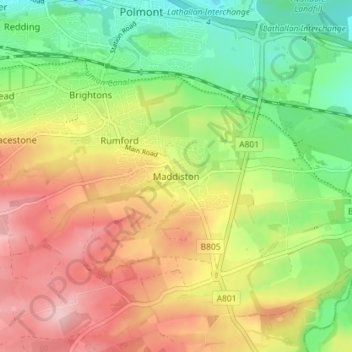
Name: Topografische Karte Maddiston, Höhe, Relief.

Ort: Maddiston, Falkirk, Scotland, FK2 0LQ, United Kingdom (55.95190 -3.72039 55.99190 -3.68039)

Durchschnittliche Höhe: 106 m

Minimale Höhe: 27 m

Maximale Höhe: 194 m

Andere topografische Karten

Klicken Sie auf eine Karte, um ihre Topografie, ihre Höhe und ihr Relief anzuzeigen.

Braes Villages

United Kingdom > Scotland > Falkirk

Durchschnittliche Höhe: 132 m

Lauriston

United Kingdom > Scotland > Falkirk

Durchschnittliche Höhe: 40 m

Union Canal

United Kingdom > Scotland > Falkirk

Canal commences from the sixteenth lock of the Forth and Clyde Navigation, about two miles west of Falkirk, in the county of Sterling , whence it takes an eastwardly course on the south side of the above-mentioned town, by some collieries; thence, through Black Hill Tunnel, and across the Glen Water, on which…

Durchschnittliche Höhe: 136 m

Wallacestone

United Kingdom > Scotland > Falkirk

Durchschnittliche Höhe: 122 m

Falkirk

United Kingdom > Scotland > Falkirk

Falkirk is located in an area of undulating topography between the Slamannan Plateau and the upper reaches of the Firth of Forth. The area to the north of Falkirk is part of the floodplain of the River Carron. Two tributaries of the River Carron - the East Burn and the West Burn flow through the town and form…

Durchschnittliche Höhe: 42 m

The Helix

United Kingdom > Scotland > Falkirk > Falkirk > Glensburgh

Durchschnittliche Höhe: 8 m

Reddingmuirhead

United Kingdom > Scotland > Falkirk

Durchschnittliche Höhe: 105 m

Black Loch

United Kingdom > Scotland > Falkirk > Blackloch

Durchschnittliche Höhe: 216 m

River Forth

United Kingdom > Scotland > Falkirk

Durchschnittliche Höhe: 140 m

Grangemouth

United Kingdom > Scotland > Falkirk

Durchschnittliche Höhe: 9 m

Shieldhill

United Kingdom > Scotland > Falkirk

Durchschnittliche Höhe: 151 m

Falkirk

United Kingdom > Scotland > Falkirk

Falkirk is located in an area of undulating topography between the Slamannan Plateau and the upper reaches of the Firth of Forth. The area to the north of Falkirk is part of the floodplain of the River Carron. Two tributaries of the River Carron - the East Burn and the West Burn flow through the town and form…

Durchschnittliche Höhe: 42 m

Rüste dich für dein nächstes Abenteuer:

💧Wasserfilter Outdoor - Sauberes Trinkwasser aus natürlichen Quellen
🧰Multitools - Vielseitige Werkzeuge für Outdoor-Einsätze
📦Dry Bags - Wasserdichte Packsäcke
🎒Rucksack 30L - Ideale Größe für Tageswanderungen
🧢Outdoor Sonnenhüte - UV-Schutz in den Bergen

Als Amazon-Partner verdient diese Website an qualifizierten Käufen, ohne zusätzliche Kosten für Sie.