
Spenden
Rüste dich für dein nächstes Abenteuer:
Als Amazon-Partner verdient diese Website an qualifizierten Käufen, ohne zusätzliche Kosten für Sie.
Topografische Karte Nesconset
Klicken Sie auf die Karte, um die Höhe anzuzeigen.
Spenden
Rüste dich für dein nächstes Abenteuer:
Als Amazon-Partner verdient diese Website an qualifizierten Käufen, ohne zusätzliche Kosten für Sie.
Über diese Karte
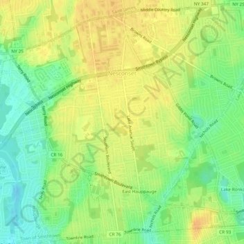
Name: Topografische Karte Nesconset, Höhe, Relief.
Durchschnittliche Höhe: 31 m
Minimale Höhe: 13 m
Maximale Höhe: 44 m
Spenden
Rüste dich für dein nächstes Abenteuer:
Als Amazon-Partner verdient diese Website an qualifizierten Käufen, ohne zusätzliche Kosten für Sie.
Andere topografische Karten
Klicken Sie auf eine Karte, um ihre Topografie, ihre Höhe und ihr Relief anzuzeigen.
Smithtown Pines
United States > New York > Suffolk County > Town of Smithtown
Durchschnittliche Höhe: 29 m
Millers Pond
United States > New York > Suffolk County > Town of Smithtown > Village of the Branch
Durchschnittliche Höhe: 20 m
Sunken Meadow
United States > New York > Suffolk County > Town of Smithtown
Durchschnittliche Höhe: 18 m
East Hauppauge
United States > New York > Suffolk County > Town of Smithtown
Durchschnittliche Höhe: 28 m
Spenden
Rüste dich für dein nächstes Abenteuer:
Als Amazon-Partner verdient diese Website an qualifizierten Käufen, ohne zusätzliche Kosten für Sie.