
Topografische Karte Pittsfield
Interaktive Karte
Klicken Sie auf die Karte, um die Höhe anzuzeigen.
Über diese Karte
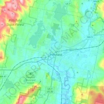
Name: Topografische Karte Pittsfield, Höhe, Relief.
Ort: Pittsfield, Berkshire County, Massachusetts, United States (42.39813 -73.33891 42.50461 -73.18220)
Durchschnittliche Höhe: 369 m
Minimale Höhe: 286 m
Maximale Höhe: 697 m
Pittsfield has a humid continental climate (Dfb). Winters are harsh due the city's high elevation at 1,039 ft (317 m), with an average annual snowfall of 75.9 inches (1,930 mm) and temperatures dipping to 0 °F (−18 °C) or colder 13 times per year. Summers, however, are typically warm and pleasant, with temperatures reaching 90 °F (32 °C) just six times per year. The record high and record low are 101 °F (38 °C) and −26 °F (−32 °C), recorded on July 23, 1926, and February 15, 1943, respectively. Over the course of a year, there are 173 days with measurable precipitation.
Andere topografische Karten
Klicken Sie auf eine Karte, um ihre Topografie, ihre Höhe und ihr Relief anzuzeigen.
Camp Kingsmont
United States > Massachusetts > Berkshire County > West Stockbridge
Camp Kingsmont, West Stockbridge, Berkshire County, Massachusetts, 01266, United States
Durchschnittliche Höhe: 421 m
Meadowvale
United States > Massachusetts > Berkshire County > Williamstown
Meadowvale, Williamstown, Berkshire County, Massachusetts, 01267, United States
Durchschnittliche Höhe: 248 m
Becket
United States > Massachusetts > Berkshire County
Becket, Berkshire County, Massachusetts, 01238, United States
Durchschnittliche Höhe: 480 m
Williamstown
United States > Massachusetts > Berkshire County > Williamstown
Williamstown, Berkshire County, Massachusetts, 01267, United States
Durchschnittliche Höhe: 433 m