
Topografische Karte Bonanza
Interaktive Karte
Klicken Sie auf die Karte, um die Höhe anzuzeigen.
Über diese Karte
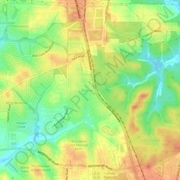
Name: Topografische Karte Bonanza, Höhe, Relief.
Ort: Bonanza, Clayton County, Georgia, 30250, United States (33.44567 -84.35659 33.48567 -84.31659)
Durchschnittliche Höhe: 272 m
Minimale Höhe: 244 m
Maximale Höhe: 297 m
Andere topografische Karten
Klicken Sie auf eine Karte, um ihre Topografie, ihre Höhe und ihr Relief anzuzeigen.
Conley
United States > Georgia > Clayton County
Conley, Clayton County, Georgia, 30288, United States
Durchschnittliche Höhe: 270 m
Morrow
United States > Georgia > Clayton County
Morrow, Clayton County, Georgia, 30260, United States
Durchschnittliche Höhe: 276 m
Mountain View
United States > Georgia > Clayton County > Coxs Crossing
Mountain View, Oak Forest, Coxs Crossing, Clayton County, Georgia, 30321, United States
Durchschnittliche Höhe: 288 m
Irondale
United States > Georgia > Clayton County
Irondale, Clayton County, Georgia, 30238, United States
Durchschnittliche Höhe: 269 m
Lake City
United States > Georgia > Clayton County
Lake City, Clayton County, Georgia, United States
Durchschnittliche Höhe: 287 m
Forest Park
United States > Georgia > Clayton County
Forest Park, Clayton County, Georgia, 30297, United States
Durchschnittliche Höhe: 283 m
Lovejoy
United States > Georgia > Clayton County
Lovejoy, Clayton County, Georgia, United States
Durchschnittliche Höhe: 275 m
Forest Park
United States > Georgia > Clayton County > Forest Park
Forest Park, Clayton County, Georgia, 30297, United States
Durchschnittliche Höhe: 283 m
Jonesboro
United States > Georgia > Clayton County
Jonesboro, Clayton County, Georgia, United States
Durchschnittliche Höhe: 269 m