
Topografische Karte Slater
Interaktive Karte
Klicken Sie auf die Karte, um die Höhe anzuzeigen.
Über diese Karte
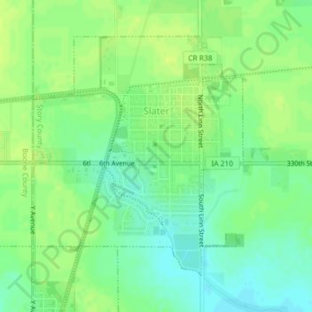
Name: Topografische Karte Slater, Höhe, Relief.
Ort: Slater, Story County, Iowa, 50244, United States (41.86808 -93.69809 41.88885 -93.67360)
Durchschnittliche Höhe: 316 m
Minimale Höhe: 307 m
Maximale Höhe: 323 m
Andere topografische Karten
Klicken Sie auf eine Karte, um ihre Topografie, ihre Höhe und ihr Relief anzuzeigen.
Kelley
United States > Iowa > Story County
Kelley, Story County, Iowa, United States
Durchschnittliche Höhe: 314 m
Ames
United States > Iowa > Story County
Ames, Story County, Iowa, United States
Durchschnittliche Höhe: 295 m
Collins
United States > Iowa > Story County
Collins, Story County, Iowa, United States
Durchschnittliche Höhe: 305 m
Ames
United States > Iowa > Story County > Ames
Ames, Story County, Iowa, 50010, United States
Durchschnittliche Höhe: 308 m
Story County
United States > Iowa > Story County
Story County, Iowa, United States
Durchschnittliche Höhe: 308 m