
Spenden
Rüste dich für dein nächstes Abenteuer:
Als Amazon-Partner verdient diese Website an qualifizierten Käufen, ohne zusätzliche Kosten für Sie.
Topografische Karte Gap Lake
Klicken Sie auf die Karte, um die Höhe anzuzeigen.
Spenden
Rüste dich für dein nächstes Abenteuer:
Als Amazon-Partner verdient diese Website an qualifizierten Käufen, ohne zusätzliche Kosten für Sie.
Über diese Karte
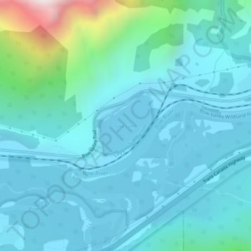
Name: Topografische Karte Gap Lake, Höhe, Relief.
Ort: Gap Lake, Municipal District of Bighorn, Alberta, Canada (51.05120 -115.23832 51.05782 -115.22819)
Durchschnittliche Höhe: 1.424 m
Minimale Höhe: 1.287 m
Maximale Höhe: 2.253 m
Spenden
Rüste dich für dein nächstes Abenteuer:
Als Amazon-Partner verdient diese Website an qualifizierten Käufen, ohne zusätzliche Kosten für Sie.
Andere topografische Karten
Klicken Sie auf eine Karte, um ihre Topografie, ihre Höhe und ihr Relief anzuzeigen.
Kananaskis
Canada > Alberta > Municipal District of Bighorn > Kananaskis
Durchschnittliche Höhe: 1.426 m
Whispering Pines Ranch
Canada > Alberta > Municipal District of Bighorn
Durchschnittliche Höhe: 1.426 m
Spenden
Rüste dich für dein nächstes Abenteuer:
Als Amazon-Partner verdient diese Website an qualifizierten Käufen, ohne zusätzliche Kosten für Sie.
Spenden
Rüste dich für dein nächstes Abenteuer:
Als Amazon-Partner verdient diese Website an qualifizierten Käufen, ohne zusätzliche Kosten für Sie.