
Topografische Karte Saint Simon Mills
Interaktive Karte
Klicken Sie auf die Karte, um die Höhe anzuzeigen.
Über diese Karte
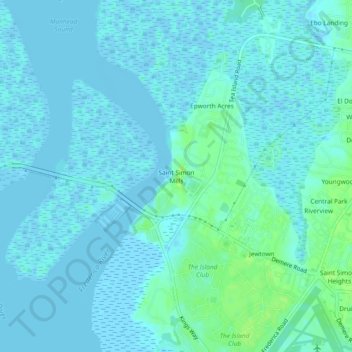
Name: Topografische Karte Saint Simon Mills, Höhe, Relief.
Durchschnittliche Höhe: 3 m
Minimale Höhe: -4 m
Maximale Höhe: 11 m
Andere topografische Karten
Klicken Sie auf eine Karte, um ihre Topografie, ihre Höhe und ihr Relief anzuzeigen.
Saint Simons Island
United States > Georgia > Glynn County
Saint Simons Island, Glynn County, Georgia, 31561, United States
Durchschnittliche Höhe: 2 m
Brunswick
United States > Georgia > Glynn County
Brunswick, Glynn County, Georgia, United States
Durchschnittliche Höhe: 2 m
Jointer Island
United States > Georgia > Glynn County > Brunswick
Jointer Island, Brunswick, Glynn County, Georgia, United States
Durchschnittliche Höhe: 0 m
Fancy Bluff
United States > Georgia > Glynn County
Fancy Bluff, Glynn County, Georgia, United States
Durchschnittliche Höhe: 3 m
Jekyll Island
United States > Georgia > Glynn County > Saint Simons
Jekyll Island, Saint Simons, Glynn County, Georgia, 31527, United States
Durchschnittliche Höhe: 1 m
Saint Simons
United States > Georgia > Glynn County
Saint Simons, Glynn County, Georgia, 31522, United States
Durchschnittliche Höhe: 2 m
Gordon Oaks Homes
United States > Georgia > Glynn County > Brunswick
Gordon Oaks Homes, Brunswick, Glynn County, Georgia, 32523, United States
Durchschnittliche Höhe: 3 m
Riverside
United States > Georgia > Glynn County > Brunswick > Riverside
Riverside, Brunswick, Glynn County, Georgia, 31520, United States
Durchschnittliche Höhe: 3 m