
Topografische Karte Tucson
Interaktive Karte
Klicken Sie auf die Karte, um die Höhe anzuzeigen.
Über diese Karte
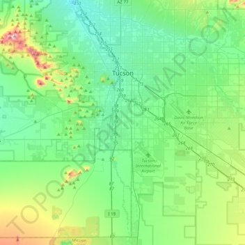
Name: Topografische Karte Tucson, Höhe, Relief.
Ort: Tucson, Pima County, Arizona, United States (31.99162 -111.05823 32.32091 -110.70821)
Durchschnittliche Höhe: 821 m
Minimale Höhe: 658 m
Maximale Höhe: 1.418 m
The city's elevation is 2,643 ft (806 m) above sea level (as measured at the Tucson International Airport). Tucson is on an alluvial plain in the Sonoran desert, surrounded by five minor ranges of mountains: the Santa Catalina Mountains and the Tortolita Mountains to the north, the Santa Rita Mountains to the south, the Rincon Mountains to the east, and the Tucson Mountains to the west. The high point of the Santa Catalina Mountains is 9,157 ft (2,791 m) Mount Lemmon, the southernmost ski destination in the continental U.S., while the Tucson Mountains include 4,687 ft (1,429 m) Wasson Peak. The highest point in the area is Mount Wrightson, found in the Santa Rita Mountains at 9,453 ft (2,881 m) above sea level.
Andere topografische Karten
Klicken Sie auf eine Karte, um ihre Topografie, ihre Höhe und ihr Relief anzuzeigen.
Isolated
United States > Arizona > Pima County
Isolated, Pima County, Arizona, United States
Durchschnittliche Höhe: 1.052 m
Catalina
United States > Arizona > Pima County
Catalina, Pima County, Arizona, 85739, United States
Durchschnittliche Höhe: 936 m