
Topografische Karte Lut Desert
Interaktive Karte
Klicken Sie auf die Karte, um die Höhe anzuzeigen.
Über diese Karte
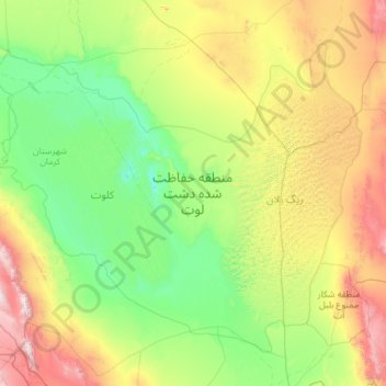
Name: Topografische Karte Lut Desert, Höhe, Relief.
Durchschnittliche Höhe: 709 m
Minimale Höhe: 145 m
Maximale Höhe: 2.868 m
The eastern part of Dasht-e Lut is a low plateau covered with salt flats with lowest elevations around 110 m above sea level (30.398609 N, 58.493041 E). In contrast, the center has been sculpted by the wind into a series of parallel ridges and furrows, extending over 150 km (93 mi) and reaching 75 metres (246 ft) in height. This area is also riddled with ravines and sinkholes. The southeast is a vast expanse of sand, like a Saharan erg, with dunes 300 metres (980 ft) high, among the tallest in the world.
Andere topografische Karten
Klicken Sie auf eine Karte, um ihre Topografie, ihre Höhe und ihr Relief anzuzeigen.
lut lake
Iran > Kerman Province > Kerman County > دهستان تکاب
lut lake, دهستان تکاب, بخش شهداد, Kerman County, Kerman Province, Iran
Durchschnittliche Höhe: 262 m