
Topografische Karte Skyline
Interaktive Karte
Klicken Sie auf die Karte, um die Höhe anzuzeigen.
Über diese Karte
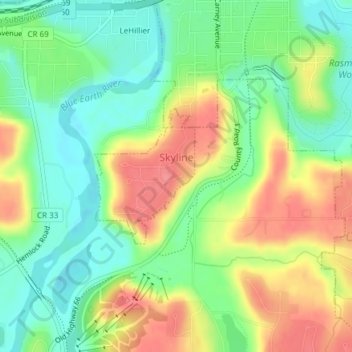
Name: Topografische Karte Skyline, Höhe, Relief.
Ort: Skyline, Blue Earth County, Minnesota, United States (44.13553 -94.03959 44.14590 -94.02884)
Durchschnittliche Höhe: 265 m
Minimale Höhe: 230 m
Maximale Höhe: 309 m
According to the U.S. Census Bureau, the city has a total area of 0.17 square miles (0.44 km2), all land. Its elevation is 980 feet (300 m) above sea-level.
Andere topografische Karten
Klicken Sie auf eine Karte, um ihre Topografie, ihre Höhe und ihr Relief anzuzeigen.
Indian Lake
United States > Minnesota > Blue Earth County
Indian Lake, Blue Earth County, Minnesota, United States
Durchschnittliche Höhe: 316 m
Mankato
United States > Minnesota > Blue Earth County > Mankato
Mankato, Blue Earth County, Minnesota, 56001, United States
Durchschnittliche Höhe: 285 m
Pemberton
United States > Minnesota > Blue Earth County
Pemberton, Blue Earth County, Minnesota, United States
Durchschnittliche Höhe: 316 m