
Topografische Karte Kernelec
Interaktive Karte
Klicken Sie auf die Karte, um die Höhe anzuzeigen.
Über diese Karte
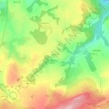
Name: Topografische Karte Kernelec, Höhe, Relief.
Durchschnittliche Höhe: 249 m
Minimale Höhe: 146 m
Maximale Höhe: 357 m
Andere topografische Karten
Klicken Sie auf eine Karte, um ihre Topografie, ihre Höhe und ihr Relief anzuzeigen.
Col de Trédudon
France > Bretagne > Finistère > Plounéour-Ménez > Baillaou
Col de Trédudon, D 36, Baillaou, Plounéour-Ménez, Morlaix, Finistère, Bretagne, France métropolitaine, 29410, France
Durchschnittliche Höhe: 315 m
Roc’h Ruz
France > Bretagne > Finistère > Plounéour-Ménez
Roc’h Ruz, Plounéour-Ménez, Morlaix, Finistère, Bretagne, France métropolitaine, 29410, France
Durchschnittliche Höhe: 309 m
Roc'h Trevezel
France > Bretagne > Finistère > Plounéour-Ménez
Roc'h Trevezel, Plounéour-Ménez, Morlaix, Finistère, Bretagne, France métropolitaine, 29410, France
Durchschnittliche Höhe: 287 m
Kersimonet
France > Bretagne > Finistère > Plounéour-Ménez
Kersimonet, Plounéour-Ménez, Morlaix, Finistère, Bretagne, France métropolitaine, 29410, France
Durchschnittliche Höhe: 242 m
Le Relecq
France > Bretagne > Finistère > Plounéour-Ménez
Le Relecq, Plounéour-Ménez, Morlaix, Finistère, Bretagne, France métropolitaine, 29410, France
Durchschnittliche Höhe: 244 m
La Caserne
France > Bretagne > Finistère > Plounéour-Ménez
La Caserne, Plounéour-Ménez, Morlaix, Finistère, Bretagne, France métropolitaine, 29410, France
Durchschnittliche Höhe: 240 m