
Topografische Karte Arrow Head
Interaktive Karte
Klicken Sie auf die Karte, um die Höhe anzuzeigen.
Über diese Karte
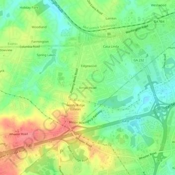
Name: Topografische Karte Arrow Head, Höhe, Relief.
Ort: Arrow Head, Columbia County, Georgia, 30907, United States (33.47847 -82.12401 33.51847 -82.08401)
Durchschnittliche Höhe: 119 m
Minimale Höhe: 86 m
Maximale Höhe: 163 m
Andere topografische Karten
Klicken Sie auf eine Karte, um ihre Topografie, ihre Höhe und ihr Relief anzuzeigen.
Windy Ridge Estates
United States > Georgia > Columbia County
Windy Ridge Estates, Columbia County, Georgia, 30907, United States
Durchschnittliche Höhe: 121 m
Snead
United States > Georgia > Columbia County
Snead, Columbia County, Georgia, United States
Durchschnittliche Höhe: 88 m
Evans
United States > Georgia > Columbia County
Evans, Columbia County, Georgia, United States
Durchschnittliche Höhe: 116 m
Grovetown
United States > Georgia > Columbia County
Grovetown, Columbia County, Georgia, United States
Durchschnittliche Höhe: 134 m
Appling
United States > Georgia > Columbia County > Appling
Appling, Columbia County, Georgia, United States
Durchschnittliche Höhe: 102 m
Westport
United States > Georgia > Columbia County
Westport, Columbia County, Georgia, 30907, United States
Durchschnittliche Höhe: 77 m