
Topografische Karte North Richland Hills
Interaktive Karte
Klicken Sie auf die Karte, um die Höhe anzuzeigen.
Über diese Karte
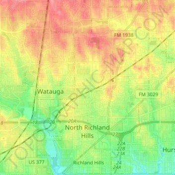
Name: Topografische Karte North Richland Hills, Höhe, Relief.
Ort: North Richland Hills, Tarrant County, Texas, United States (32.80874 -97.26452 32.91152 -97.18592)
Durchschnittliche Höhe: 191 m
Minimale Höhe: 154 m
Maximale Höhe: 230 m
Andere topografische Karten
Klicken Sie auf eine Karte, um ihre Topografie, ihre Höhe und ihr Relief anzuzeigen.
USA
United States > Texas > Tarrant County > Arlington
USA, Arlington, Tarrant County, Texas, 76011, United States
Durchschnittliche Höhe: 170 m
Boomtown
United States > Texas > Tarrant County > Arlington
Boomtown, Arlington, Tarrant County, Texas, 76006, United States
Durchschnittliche Höhe: 170 m
Luther Lake
United States > Texas > Tarrant County > Fort Worth
Luther Lake, Fort Worth, Tarrant County, Texas, United States
Durchschnittliche Höhe: 212 m
Southwind
United States > Texas > Tarrant County > Arlington
Southwind, Arlington, Tarrant County, Texas, 76002, United States
Durchschnittliche Höhe: 175 m
White Settlement
United States > Texas > Tarrant County
White Settlement, Tarrant County, Texas, United States
Durchschnittliche Höhe: 211 m
Forest Hill
United States > Texas > Tarrant County
Forest Hill, Tarrant County, Texas, United States
Durchschnittliche Höhe: 198 m
Azle
United States > Texas > Tarrant County
Azle, Tarrant County, Texas, 76020, United States
Durchschnittliche Höhe: 223 m
Fort Worth
United States > Texas > Tarrant County > Fort Worth
Fort Worth, Tarrant County, Texas, 76102, United States
Durchschnittliche Höhe: 202 m