
Spenden
Rüste dich für dein nächstes Abenteuer:
Als Amazon-Partner verdient diese Website an qualifizierten Käufen, ohne zusätzliche Kosten für Sie.
Topografische Karte Balanga
Klicken Sie auf die Karte, um die Höhe anzuzeigen.
Spenden
Rüste dich für dein nächstes Abenteuer:
Als Amazon-Partner verdient diese Website an qualifizierten Käufen, ohne zusätzliche Kosten für Sie.
Über diese Karte
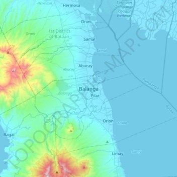
Name: Topografische Karte Balanga, Höhe, Relief.
Ort: Balanga, Bataan, Central Luzon, 2100, Philippines (14.51957 120.38097 14.83957 120.70097)
Durchschnittliche Höhe: 134 m
Minimale Höhe: -3 m
Maximale Höhe: 1.345 m
Spenden
Rüste dich für dein nächstes Abenteuer:
Als Amazon-Partner verdient diese Website an qualifizierten Käufen, ohne zusätzliche Kosten für Sie.
Andere topografische Karten
Klicken Sie auf eine Karte, um ihre Topografie, ihre Höhe und ihr Relief anzuzeigen.
Spenden
Rüste dich für dein nächstes Abenteuer:
Als Amazon-Partner verdient diese Website an qualifizierten Käufen, ohne zusätzliche Kosten für Sie.
Spenden
Rüste dich für dein nächstes Abenteuer:
Als Amazon-Partner verdient diese Website an qualifizierten Käufen, ohne zusätzliche Kosten für Sie.
Morong
The most probable etymology comes from the Spanish word morón which refers to a hill which can be seen from the sea. Several towns in Spain and in Spanish colonies are also named Morón, namely Morón in Cuba; Morón de la Fronterra in Sevilla, Spain; and Morón in Buenos Aires, Argentina, to name a few.…
Durchschnittliche Höhe: 110 m
Spenden
Rüste dich für dein nächstes Abenteuer:
Als Amazon-Partner verdient diese Website an qualifizierten Käufen, ohne zusätzliche Kosten für Sie.
Abucay
Topography of Abucay varies from the mountainous terrain of Mount Natib caldera in the west to the coastal areas of the province along the shore of Manila Bay. Six rivers with a combined length of 37 kilometres (23 mi) originate from the mountain flowing in the west-to-east direction.
Durchschnittliche Höhe: 70 m
Spenden
Rüste dich für dein nächstes Abenteuer:
Als Amazon-Partner verdient diese Website an qualifizierten Käufen, ohne zusätzliche Kosten für Sie.
Spenden
Rüste dich für dein nächstes Abenteuer:
Als Amazon-Partner verdient diese Website an qualifizierten Käufen, ohne zusätzliche Kosten für Sie.
Roosevelt Protected Landscape
Philippines > Bataan > Dinalupihan > Roosevelt
Durchschnittliche Höhe: 148 m
Spenden
Rüste dich für dein nächstes Abenteuer:
Als Amazon-Partner verdient diese Website an qualifizierten Käufen, ohne zusätzliche Kosten für Sie.
Spenden
Rüste dich für dein nächstes Abenteuer:
Als Amazon-Partner verdient diese Website an qualifizierten Käufen, ohne zusätzliche Kosten für Sie.
Spenden
Rüste dich für dein nächstes Abenteuer:
Als Amazon-Partner verdient diese Website an qualifizierten Käufen, ohne zusätzliche Kosten für Sie.
Abucay
Topography of Abucay varies from the mountainous terrain of Mount Natib caldera in the west to the coastal areas of the province along the shore of Manila Bay. Six rivers with a combined length of 37 kilometres (23 mi) originate from the mountain flowing in the west-to-east direction.
Durchschnittliche Höhe: 70 m
Spenden
Rüste dich für dein nächstes Abenteuer:
Als Amazon-Partner verdient diese Website an qualifizierten Käufen, ohne zusätzliche Kosten für Sie.
Spenden
Rüste dich für dein nächstes Abenteuer:
Als Amazon-Partner verdient diese Website an qualifizierten Käufen, ohne zusätzliche Kosten für Sie.
Spenden
Rüste dich für dein nächstes Abenteuer:
Als Amazon-Partner verdient diese Website an qualifizierten Käufen, ohne zusätzliche Kosten für Sie.
Morong
The most probable etymology comes from the Spanish word morón which refers to a hill which can be seen from the sea. Several towns in Spain and in Spanish colonies are also named Morón, namely Morón in Cuba; Morón de la Fronterra in Sevilla, Spain; and Morón in Buenos Aires, Argentina, to name a few.…
Durchschnittliche Höhe: 110 m
Abucay
The topography of Abucay varies from the mountainous terrain of Mount Natib caldera in the west to the coastal areas of the province along the shore of Manila Bay. Six rivers with a combined length of 37 kilometres (23 mi) originate from the mountain flowing in the west-to-east direction.
Durchschnittliche Höhe: 70 m
Spenden
Rüste dich für dein nächstes Abenteuer:
Als Amazon-Partner verdient diese Website an qualifizierten Käufen, ohne zusätzliche Kosten für Sie.
Abucay
Topography of Abucay varies from the mountainous terrain of Mount Natib caldera in the west to the coastal areas of the province along the shore of Manila Bay. Six rivers with a combined length of 37 kilometres (23 mi) originate from the mountain flowing in the west-to-east direction.
Durchschnittliche Höhe: 140 m
Spenden
Rüste dich für dein nächstes Abenteuer:
Als Amazon-Partner verdient diese Website an qualifizierten Käufen, ohne zusätzliche Kosten für Sie.
Morong
The most probable etymology comes from the Spanish word morón which refers to a hill which can be seen from the sea. Several towns in Spain and in Spanish colonies are also named Morón, namely Morón in Cuba; Morón de la Fronterra in Sevilla, Spain; and Morón in Buenos Aires, Argentina, to name a few.…
Durchschnittliche Höhe: 111 m
Spenden
Rüste dich für dein nächstes Abenteuer:
Als Amazon-Partner verdient diese Website an qualifizierten Käufen, ohne zusätzliche Kosten für Sie.
Spenden
Rüste dich für dein nächstes Abenteuer:
Als Amazon-Partner verdient diese Website an qualifizierten Käufen, ohne zusätzliche Kosten für Sie.