
Topografische Karte Stockholm
Interaktive Karte
Klicken Sie auf die Karte, um die Höhe anzuzeigen.
Über diese Karte
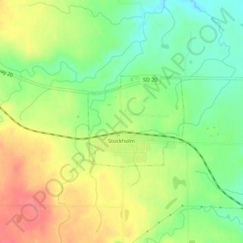
Name: Topografische Karte Stockholm, Höhe, Relief.
Ort: Stockholm, Grant County, South Dakota, United States (45.09675 -96.80729 45.10688 -96.79211)
Durchschnittliche Höhe: 503 m
Minimale Höhe: 470 m
Maximale Höhe: 540 m
Andere topografische Karten
Klicken Sie auf eine Karte, um ihre Topografie, ihre Höhe und ihr Relief anzuzeigen.
La Bolt
United States > South Dakota > Grant County
La Bolt, Grant County, South Dakota, United States
Durchschnittliche Höhe: 418 m
Big Stone City
United States > South Dakota > Grant County
Big Stone City, Grant County, South Dakota, United States
Durchschnittliche Höhe: 314 m
Strandburg
United States > South Dakota > Grant County
Strandburg, Grant County, South Dakota, United States
Durchschnittliche Höhe: 512 m
Twin Brooks
United States > South Dakota > Grant County
Twin Brooks, Grant County, South Dakota, United States
Durchschnittliche Höhe: 385 m
Milbank
United States > South Dakota > Grant County
Milbank, Grant County, South Dakota, United States
Durchschnittliche Höhe: 350 m
Revillo
United States > South Dakota > Grant County
Revillo, Grant County, South Dakota, United States
Durchschnittliche Höhe: 369 m
Marvin
United States > South Dakota > Grant County
Marvin, Grant County, South Dakota, United States
Durchschnittliche Höhe: 501 m