
Topografische Karte Atlantic Beach
Interaktive Karte
Klicken Sie auf die Karte, um die Höhe anzuzeigen.
Über diese Karte
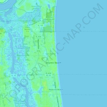
Name: Topografische Karte Atlantic Beach, Höhe, Relief.
Ort: Atlantic Beach, Duval County, Florida, 32233, United States (30.32343 -81.43873 30.36103 -81.33418)
Durchschnittliche Höhe: 2 m
Minimale Höhe: -4 m
Maximale Höhe: 10 m
Andere topografische Karten
Klicken Sie auf eine Karte, um ihre Topografie, ihre Höhe und ihr Relief anzuzeigen.
Ribault River
United States > Florida > Duval County > Jacksonville > Lake Forest Hills
Ribault River, Lake Forest Hills, Jacksonville, Duval County, Florida, United States
Durchschnittliche Höhe: 7 m
Stockade
United States > Florida > Duval County > Jacksonville
Stockade, Jacksonville, Duval County, Florida, 32256, United States
Durchschnittliche Höhe: 12 m
Little Talbot Island State Park
United States > Florida > Duval County > Jacksonville
Little Talbot Island State Park, Buccaneer Trail, Jacksonville, Duval County, Florida, 32228, United States
Durchschnittliche Höhe: 1 m
San Jose
United States > Florida > Duval County > Jacksonville > San Jose
San Jose, Jacksonville, Duval County, Florida, 32217, United States
Durchschnittliche Höhe: 7 m
Jacksonville
United States > Florida > Duval County
Jacksonville, Duval County, Florida, United States
Durchschnittliche Höhe: 10 m
Larsen
United States > Florida > Duval County > Jacksonville > Larsen
Larsen, Jacksonville, Duval County, Florida, 32207, United States
Durchschnittliche Höhe: 9 m
Jacksonville
United States > Florida > Duval County > Jacksonville
Jacksonville, Duval County, Florida, 32202, United States
Durchschnittliche Höhe: 9 m
Trout River
United States > Florida > Duval County > Jacksonville
Trout River, Jacksonville, Duval County, Florida, 32208, United States
Durchschnittliche Höhe: 7 m