
Topografische Karte Ward 2
Interaktive Karte
Klicken Sie auf die Karte, um die Höhe anzuzeigen.
Über diese Karte
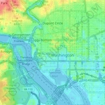
Name: Topografische Karte Ward 2, Höhe, Relief.
Ort: Ward 2, Washington, District of Columbia, United States (38.87108 -77.08185 38.92139 -77.01481)
Durchschnittliche Höhe: 23 m
Minimale Höhe: -3 m
Maximale Höhe: 96 m
Andere topografische Karten
Klicken Sie auf eine Karte, um ihre Topografie, ihre Höhe und ihr Relief anzuzeigen.
Capitol Hill
United States > District of Columbia > Washington
Capitol Hill, Washington, District of Columbia, 20215, United States
Durchschnittliche Höhe: 18 m
Ward 5
United States > District of Columbia > Washington
Ward 5, Washington, District of Columbia, United States
Durchschnittliche Höhe: 35 m
National Christmas Tree
United States > District of Columbia > Washington
National Christmas Tree, Ellipse Road Northwest, Ward 2, Washington, District of Columbia, 20500, United States
Durchschnittliche Höhe: 19 m
Rock Creek Park and Piney Branch Parkway
United States > District of Columbia > Washington
Rock Creek Park and Piney Branch Parkway, Washington, District of Columbia, United States
Durchschnittliche Höhe: 83 m
United States National Arboretum
United States > District of Columbia > Washington
United States National Arboretum, Arboretum, Washington, District of Columbia, United States
Durchschnittliche Höhe: 21 m
Good Hope Hill
United States > District of Columbia > Washington
Good Hope Hill, Washington, District of Columbia, 20020, United States
Durchschnittliche Höhe: 52 m
Point Reno
United States > District of Columbia > Washington
Point Reno, Washington, District of Columbia, 20016-2137, United States
Durchschnittliche Höhe: 98 m