
Topografische Karte Ryderwood
Interaktive Karte
Klicken Sie auf die Karte, um die Höhe anzuzeigen.
Über diese Karte
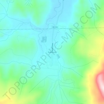
Name: Topografische Karte Ryderwood, Höhe, Relief.
Durchschnittliche Höhe: 158 m
Minimale Höhe: 52 m
Maximale Höhe: 491 m
Andere topografische Karten
Klicken Sie auf eine Karte, um ihre Topografie, ihre Höhe und ihr Relief anzuzeigen.
Toutle River Sediment Retention Structure
United States > Washington > Cowlitz County
Toutle River Sediment Retention Structure, Cowlitz County, Washington, United States
Durchschnittliche Höhe: 347 m
Kalama
United States > Washington > Cowlitz County
Kalama, Cowlitz County, Washington, 98625, United States
Durchschnittliche Höhe: 58 m
Ariel
United States > Washington > Cowlitz County
Ariel, Cowlitz County, Washington, United States
Durchschnittliche Höhe: 206 m
Woodland
United States > Washington > Cowlitz County
Woodland, Cowlitz County, Washington, 98674, United States
Durchschnittliche Höhe: 36 m
Yale
United States > Washington > Cowlitz County
Yale, Cowlitz County, Washington, 98603, United States
Durchschnittliche Höhe: 257 m
Castle Rock
United States > Washington > Cowlitz County
Castle Rock, Cowlitz County, Washington, 98611, United States
Durchschnittliche Höhe: 55 m
Cougar
United States > Washington > Cowlitz County
Cougar, Cowlitz County, Washington, 98616, United States
Durchschnittliche Höhe: 311 m
Kelso
United States > Washington > Cowlitz County
Kelso, Cowlitz County, Washington, 98626, United States
Durchschnittliche Höhe: 52 m