
Topografische Karte Platteville
Interaktive Karte
Klicken Sie auf die Karte, um die Höhe anzuzeigen.
Über diese Karte
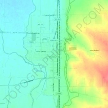
Name: Topografische Karte Platteville, Höhe, Relief.
Ort: Platteville, Weld County, Colorado, États-Unis d'Amérique (40.19948 -104.86751 40.23264 -104.81056)
Durchschnittliche Höhe: 1.475 m
Minimale Höhe: 1.454 m
Maximale Höhe: 1.516 m
Andere topografische Karten
Klicken Sie auf eine Karte, um ihre Topografie, ihre Höhe und ihr Relief anzuzeigen.
Windsor
États-Unis d'Amérique > Colorado > Weld County
Windsor, Weld County, Colorado, 80550, États-Unis d'Amérique
Durchschnittliche Höhe: 1.485 m
Fort Lupton
États-Unis d'Amérique > Colorado > Weld County
Fort Lupton, Weld County, Colorado, 80621, États-Unis d'Amérique
Durchschnittliche Höhe: 1.512 m