
Topografische Karte Saxtons River
Interaktive Karte
Klicken Sie auf die Karte, um die Höhe anzuzeigen.
Über diese Karte
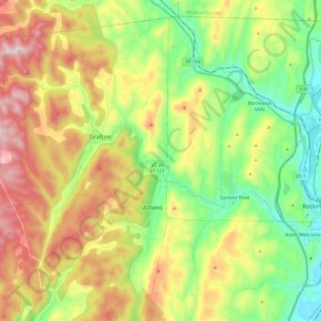
Name: Topografische Karte Saxtons River, Höhe, Relief.
Durchschnittliche Höhe: 321 m
Minimale Höhe: 66 m
Maximale Höhe: 689 m
The Saxtons River is a 22.9-mile-long (36.9 km) river in the U.S. state of Vermont, a tributary of the Connecticut River. Its watershed covers 78 square miles (200 km2) and a range in altitude of 1,800 feet (550 m); land use is about 80% forested and 3% agricultural, and the upper river supports wild brook trout and brown trout, while Atlantic salmon occur but are usually limited to the area below Twin Falls on the lower river.