
Spenden
Rüste dich für dein nächstes Abenteuer:
Als Amazon-Partner verdient diese Website an qualifizierten Käufen, ohne zusätzliche Kosten für Sie.
Topografische Karte Tengboche
Klicken Sie auf die Karte, um die Höhe anzuzeigen.
Spenden
Rüste dich für dein nächstes Abenteuer:
Als Amazon-Partner verdient diese Website an qualifizierten Käufen, ohne zusätzliche Kosten für Sie.
Tengboche
Tengboche is located on a hill at the confluence of the Dudh Kosi and the Imja Khola rivers. It lies in Solukhumbu district to the north east of Kathmandu on the Nepal – Tibet border. It is inhabited by sherpas ('sherpa' literally means the easterner) who migrated from Tibet six hundred years ago. It is approached by a mountain trail from Namche, the nearest airport in Lukla (2,800 metres (9,200 ft)) connecting to Kathmandu. It is about two days of trekking from Lukla. However, considering acclimatization needs for the high altitude climbing, a four-day trekking is generally preferred. This trail crosses initially the Dudh Kosi (3,250 metres (10,660 ft)) river and a further climb leads to the Tengboche monastery at 3,870 metres (12,700 ft) altitude. However, a down hill trek leads to Devouche, the nunnery. During the winter, the snow peaks of Ama Dablam, the tip of the Everest that glows from the Nuptse ridge and several other peaks form a picturesque landscape.
Spenden
Rüste dich für dein nächstes Abenteuer:
Als Amazon-Partner verdient diese Website an qualifizierten Käufen, ohne zusätzliche Kosten für Sie.
Über diese Karte
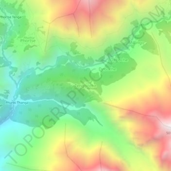
Name: Topografische Karte Tengboche, Höhe, Relief.
Durchschnittliche Höhe: 3.936 m
Minimale Höhe: 3.215 m
Maximale Höhe: 4.970 m
Spenden
Rüste dich für dein nächstes Abenteuer:
Als Amazon-Partner verdient diese Website an qualifizierten Käufen, ohne zusätzliche Kosten für Sie.
Andere topografische Karten
Klicken Sie auf eine Karte, um ihre Topografie, ihre Höhe und ihr Relief anzuzeigen.
Spenden
Rüste dich für dein nächstes Abenteuer:
Als Amazon-Partner verdient diese Website an qualifizierten Käufen, ohne zusätzliche Kosten für Sie.