
Topografische Karte Pagar Alam
Interaktive Karte
Klicken Sie auf die Karte, um die Höhe anzuzeigen.
Über diese Karte
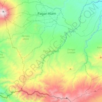
Name: Topografische Karte Pagar Alam, Höhe, Relief.
Ort: Pagar Alam, South Sumatra, Indonesia (-4.26717 103.13002 -3.98478 103.41541)
Durchschnittliche Höhe: 1.293 m
Minimale Höhe: 443 m
Maximale Höhe: 3.151 m
Pagaralam is located by the Bukit Barisan Mountains, at the feet of Mount Dempo. Much of the soil in the city consists of latosol and andisol with rugged and hilly topography. The soil in this city is classified as soil with high fertility (class I).