
Topografische Karte Lakewood
Interaktive Karte
Klicken Sie auf die Karte, um die Höhe anzuzeigen.
Über diese Karte
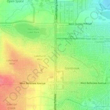
Name: Topografische Karte Lakewood, Höhe, Relief.
Ort: Lakewood, Jefferson County, Colorado, United States (39.62697 -105.11032 39.63519 -105.10987)
Durchschnittliche Höhe: 1.717 m
Minimale Höhe: 1.681 m
Maximale Höhe: 1.758 m
Lakewood is located at 39°42′17″N 105°04′53″W / 39.70472°N 105.08139°W / 39.70472; -105.08139 at an elevation of 5,518 feet (1,682 m). Located at the junction of U.S. Route 6 and Colorado State Highway 121 in central Colorado, the city lies immediately west of Denver and 62 miles (100 km) north-northwest of Colorado Springs.