
Topografische Karte McDowell
Interaktive Karte
Klicken Sie auf die Karte, um die Höhe anzuzeigen.
Über diese Karte
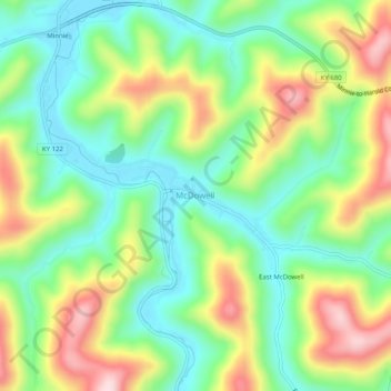
Name: Topografische Karte McDowell, Höhe, Relief.
Ort: McDowell, Floyd County, Kentucky, 41647, United States (37.43593 -82.75627 37.47593 -82.71627)
Durchschnittliche Höhe: 324 m
Minimale Höhe: 205 m
Maximale Höhe: 519 m
Andere topografische Karten
Klicken Sie auf eine Karte, um ihre Topografie, ihre Höhe und ihr Relief anzuzeigen.
Weeksbury
United States > Kentucky > Floyd County
Weeksbury, Floyd County, Kentucky, 41669, United States
Durchschnittliche Höhe: 487 m
Warco
United States > Kentucky > Floyd County
Warco, Floyd County, Kentucky, 41645, United States
Durchschnittliche Höhe: 269 m
Harold
United States > Kentucky > Floyd County
Harold, Floyd County, Kentucky, 41635, United States
Durchschnittliche Höhe: 268 m
Eastern
United States > Kentucky > Floyd County
Eastern, Floyd County, Kentucky, 41622, United States
Durchschnittliche Höhe: 274 m