
Topografische Karte Cagbuhangin
Interaktive Karte
Klicken Sie auf die Karte, um die Höhe anzuzeigen.
Über diese Karte
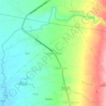
Name: Topografische Karte Cagbuhangin, Höhe, Relief.
Durchschnittliche Höhe: 66 m
Minimale Höhe: 14 m
Maximale Höhe: 159 m
Andere topografische Karten
Klicken Sie auf eine Karte, um ihre Topografie, ihre Höhe und ihr Relief anzuzeigen.
Green Valley
Philippines > Leyte > Ormoc
Green Valley, Ormoc, 4th District, Leyte, Eastern Visayas, 6541, Philippines
Durchschnittliche Höhe: 81 m
Binahaan River
Philippines > Leyte > Ormoc
Binahaan River, Ormoc, Leyte 4th District, Leyte, Eastern Visayas, 6541, Philippines
Durchschnittliche Höhe: 516 m
Lake Danao
Philippines > Leyte > Ormoc
Lake Danao, Ormoc, Leyte 4th District, Leyte, Eastern Visayas, 6541, Philippines
Durchschnittliche Höhe: 729 m
Malbasag River
Philippines > Leyte > Ormoc
Malbasag River, Ormoc, Leyte 4th District, Leyte, Eastern Visayas, 6541, Philippines
Durchschnittliche Höhe: 200 m
Pagsangahan River
Philippines > Leyte > Ormoc
Pagsangahan River, Ormoc, Leyte 4th District, Leyte, Eastern Visayas, 6541, Philippines
Durchschnittliche Höhe: 2 m
Anilao River
Philippines > Leyte > Ormoc
Anilao River, Ormoc, Leyte 4th District, Leyte, Eastern Visayas, 6541, Philippines
Durchschnittliche Höhe: 80 m
Cambantog
Philippines > Leyte > Ormoc > Cambantog
Cambantog, Ormoc, Leyte 4th District, Leyte, Eastern Visayas, 6541, Philippines
Durchschnittliche Höhe: 729 m
Ormoc
Philippines > Leyte > Ormoc
Ormoc, Leyte 4th District, Leyte, Eastern Visayas, 6541, Philippines
Durchschnittliche Höhe: 201 m