
Topografische Karte Abbey St. Bathans
Interaktive Karte
Klicken Sie auf die Karte, um die Höhe anzuzeigen.
Abbey St. Bathans
Abbey St Bathans (Scottish Gaelic: Abaid Bhaoithin) is a parish in the Lammermuir district of Berwickshire, in the eastern part of the Scottish Borders. Unique in its topography, it is situated in a long winding steep wooded valley that follows the Whiteadder Water. The parish had a population of 106 at the 2011 Census.
Über diese Karte
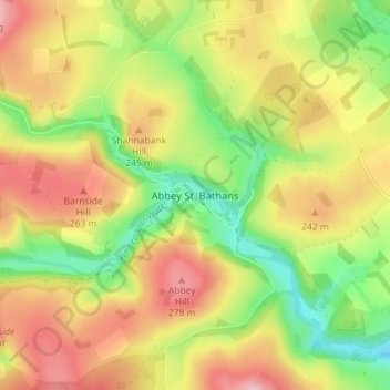
Name: Topografische Karte Abbey St. Bathans, Höhe, Relief.
Durchschnittliche Höhe: 212 m
Minimale Höhe: 128 m
Maximale Höhe: 296 m