
Topografische Karte Eastern West Khasi Hills District
Interaktive Karte
Klicken Sie auf die Karte, um die Höhe anzuzeigen.
Über diese Karte
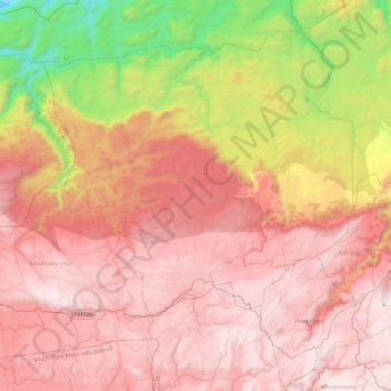
Name: Topografische Karte Eastern West Khasi Hills District, Höhe, Relief.
Ort: Eastern West Khasi Hills District, Meghalaya, 793120, India (25.46964 91.34291 25.82786 91.81415)
Durchschnittliche Höhe: 1.176 m
Minimale Höhe: 59 m
Maximale Höhe: 1.952 m
The Mawthadraishan Range runs east to west through the district. The highest elevation in the district is Mawthadraishan Peak at 1,924.5 metres (6,314 ft) above sea level, located approximately midway between the towns of Nongstoin and Mairang. Another notable elevation in the district is Kyllang Rock, a large granitic dome located 9 kilometres (5.6 mi) northwest of Mairang at 1,774 metres (5,820 ft) above sea level. This rock is personified as a man in various Khasi legends: one says that he is married to Thadlaskein Lake near Jowai, and another describes his battles with Symper Rock to the south near Mawkyrwat.
Andere topografische Karten
Klicken Sie auf eine Karte, um ihre Topografie, ihre Höhe und ihr Relief anzuzeigen.
Khasi Hills
India > Meghalaya > Mawshynrut
Khasi Hills, Mawshynrut, West Khasi Hills District, Meghalaya, India
Durchschnittliche Höhe: 349 m
South Garo Hills
South Garo Hills, Meghalaya, 794102, India
Durchschnittliche Höhe: 282 m