
Topografische Karte Meteora
Interaktive Karte
Klicken Sie auf die Karte, um die Höhe anzuzeigen.
Über diese Karte
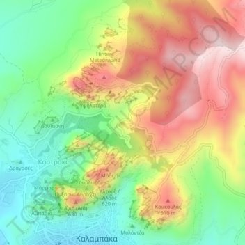
Name: Topografische Karte Meteora, Höhe, Relief.
Durchschnittliche Höhe: 429 m
Minimale Höhe: 227 m
Maximale Höhe: 678 m
The Monastery of Rousanou is believed to have been constructed, like many of the other monasteries, in the 14th century. The cathedral is believed to have been built in the 16th century and later decorated in 1540. The name Rousanou is believed to come from the first group of monks who settled on the rock from Russia. The monastery sits on the elevation 484 meters. Lying in the middle of the site, visitors can see the other monasteries, as well as the ruins of the Monastery of St. John the Baptist and the Pantokrator.