
Topografische Karte Le Breuil - Cervinia
Interaktive Karte
Klicken Sie auf die Karte, um die Höhe anzuzeigen.
Über diese Karte
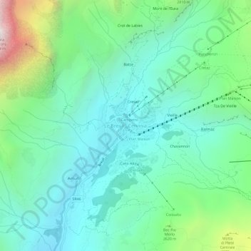
Name: Topografische Karte Le Breuil - Cervinia, Höhe, Relief.
Ort: Le Breuil - Cervinia, Valtournenche, Aosta Valley, 11021, Italy (45.91560 7.61044 45.95560 7.65044)
Durchschnittliche Höhe: 2.376 m
Minimale Höhe: 1.914 m
Maximale Höhe: 3.806 m
The ski area is very large and guarantees good snow quality during the season, being at a high altitude (2,050 m to 3,500 m).
Andere topografische Karten
Klicken Sie auf eine Karte, um ihre Topografie, ihre Höhe und ihr Relief anzuzeigen.
Valtournenche
Italy > Aosta Valley > Valtournenche
Valtournenche, Aosta Valley, Italy
Durchschnittliche Höhe: 2.640 m
Courmayeur
Italy > Aosta Valley > Courmayeur
Courmayeur, Aosta Valley, 11013, Italy
Durchschnittliche Höhe: 2.367 m
Torrente
Italy > Aosta Valley > Bionaz
Torrente, Bionaz, Aosta Valley, Italy
Durchschnittliche Höhe: 2.448 m
Matterhorn
Italy > Aosta Valley > Valtournenche
Matterhorn, Valtournenche, Aosta Valley, Italy
Durchschnittliche Höhe: 3.295 m
Dent d'Hérens
Italy > Aosta Valley > Bionaz
Dent d'Hérens, Bionaz, Aosta Valley, Italy
Durchschnittliche Höhe: 3.354 m
Gran Paradiso
Italy > Aosta Valley > Valsavarenche
Gran Paradiso, Valsavarenche, Aosta Valley, Italy
Durchschnittliche Höhe: 3.459 m
Ghiacciaio del Miage
Italy > Aosta Valley > Courmayeur
Ghiacciaio del Miage, Sentiero 15 Rifugio Gonella, Courmayeur, Aosta Valley, Italy
Durchschnittliche Höhe: 2.911 m