
Topografische Karte Puerto Carreño
Interaktive Karte
Klicken Sie auf die Karte, um die Höhe anzuzeigen.
Puerto Carreño
The area of the municipality is within the llanos plains which cover large areas in Colombia and Venezuela that are rich in biodiversity. Geologically the municipality of Puerto Carreño lies on the Guiana Shield mostly made up by Cenozoic and Precambric formations, with some low altitude mountains such as the Mounts of Casuarito and the Hormiga and Guaripa mountains.
Über diese Karte
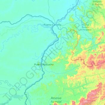
Name: Topografische Karte Puerto Carreño, Höhe, Relief.
Ort: Puerto Carreño, Vichada, RAP Llanos, Colombia (5.30179 -68.82483 6.32878 -67.40844)
Durchschnittliche Höhe: 194 m
Minimale Höhe: 32 m
Maximale Höhe: 1.599 m
Andere topografische Karten
Klicken Sie auf eine Karte, um ihre Topografie, ihre Höhe und ihr Relief anzuzeigen.