
Spenden
Rüste dich für dein nächstes Abenteuer:
Als Amazon-Partner verdient diese Website an qualifizierten Käufen, ohne zusätzliche Kosten für Sie.
Topografische Karte Laytonville
Klicken Sie auf die Karte, um die Höhe anzuzeigen.
Spenden
Rüste dich für dein nächstes Abenteuer:
Als Amazon-Partner verdient diese Website an qualifizierten Käufen, ohne zusätzliche Kosten für Sie.
Laytonville
Laytonville is a census-designated place (CDP) in Mendocino County, California, United States. It is located 23 miles (37 km) north-northwest of Willits, at an elevation of 1,670 feet (510 m). The population was 1,152 at the 2020 census, down from 1,227 at the 2010 census.
Spenden
Rüste dich für dein nächstes Abenteuer:
Als Amazon-Partner verdient diese Website an qualifizierten Käufen, ohne zusätzliche Kosten für Sie.
Über diese Karte
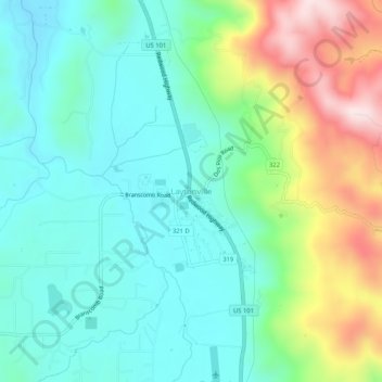
Name: Topografische Karte Laytonville, Höhe, Relief.
Durchschnittliche Höhe: 594 m
Minimale Höhe: 466 m
Maximale Höhe: 908 m
Spenden
Rüste dich für dein nächstes Abenteuer:
Als Amazon-Partner verdient diese Website an qualifizierten Käufen, ohne zusätzliche Kosten für Sie.
Andere topografische Karten
Klicken Sie auf eine Karte, um ihre Topografie, ihre Höhe und ihr Relief anzuzeigen.
Fort Bragg
United States > California > Mendocino County
Fort Bragg, officially the City of Fort Bragg, is a city along the Pacific Coast of California along Shoreline Highway in Mendocino County. The city is 24 miles (39 km) west of Willits, at an elevation of 85 feet (26 m). Its population was 6,983 at the 2020 census.
Durchschnittliche Höhe: 8 m
Talmage
United States > California > Mendocino County
Talmage (variant, Talmadge) is a census-designated place (CDP) in Mendocino County, California, United States. Talmage is located 2.5 miles (4 km) east-southeast of Ukiah, at an elevation of 627 feet (191 m). The population was 986 at the 2020 census, down from 1,130 in 2010. It lies in the southeastern part…
Durchschnittliche Höhe: 200 m
Fort Bragg
United States > California > Mendocino County
Fort Bragg is a city along the Pacific Coast of California along Shoreline Highway in Mendocino County. The city is 24 miles (39 km) west of Willits, at an elevation of 85 feet (26 m). Its population was 6,983 at the 2020 census.
Durchschnittliche Höhe: 24 m
Fort Bragg
United States > California > Mendocino County
Fort Bragg is a city along the North Coast of California along in Mendocino County. The city is 24 miles (39 km) west of Willits, at an elevation of 85 feet (26 m). Its population was 6,983 at the 2020 census.
Durchschnittliche Höhe: 29 m
Spenden
Rüste dich für dein nächstes Abenteuer:
Als Amazon-Partner verdient diese Website an qualifizierten Käufen, ohne zusätzliche Kosten für Sie.
Point Arena
United States > California > Mendocino County
Point Arena, formerly known as Punta Arena (Spanish for "Sandy Point") is a small coastal city in Mendocino County, California, United States. Point Arena is located 32 miles (51 km) west of Hopland, at an elevation of 118 feet (36 m). The population was 460 at the 2020 census, making it one of the smallest…
Durchschnittliche Höhe: 12 m
East Fork Russian River
United States > California > Mendocino County > Potter Valley
Durchschnittliche Höhe: 412 m
Point Arena
United States > California > Mendocino County
Point Arena, formerly known as Punta Arena (Spanish for "Sandy Point") is a small coastal city in Mendocino County, California, United States. Point Arena is located 32 miles (51 km) west of Hopland, at an elevation of 118 feet (36 m). The population was 460 at the 2020 census, making it one of the smallest…
Durchschnittliche Höhe: 51 m
Russian River
United States > California > Mendocino County > Redwood Valley
Durchschnittliche Höhe: 428 m
Spenden
Rüste dich für dein nächstes Abenteuer:
Als Amazon-Partner verdient diese Website an qualifizierten Käufen, ohne zusätzliche Kosten für Sie.
Hopland
United States > California > Mendocino County > Hopland
Hopland (formerly Sanel) is a census-designated place in Mendocino County, California, United States. It is located on the west bank of the Russian River 13 miles (21 km) south-southeast of Ukiah, in the Sanel Valley, at an elevation of 502 feet (153 m). The population was 661 at the 2020 census, down from 756…
Durchschnittliche Höhe: 165 m