
Topografische Karte Monterrey
Interaktive Karte
Klicken Sie auf die Karte, um die Höhe anzuzeigen.
Monterrey
The region corresponds to a folded structural system whose height and shape is caused by the action of tectonic forces on a set of sedimentary rocks of different composition, which are being affected by denudative phenomena. The mountains are located on the western side of the municipality. Due to tectonic activity of the region, the topography can be abrupt, with slopes greater than 45%. Heights of the mountains range from 800 to 2000 MASL also due to unstable tectonics. Monterrey is home to many Monoclinal ridges corresponding to elongated forms in the form of asymmetric blades that protrude due to their height within the mountainous system. They are escarpments whose structural slopes are regular due to the uniformity and hardness of the rocks that conform it, corresponding to elongated blades of high slope and edges associated with sandstone.
Über diese Karte
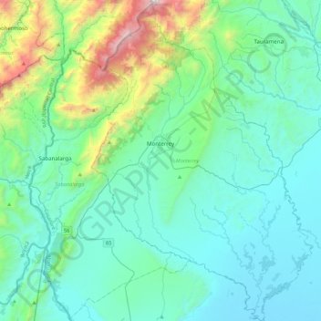
Name: Topografische Karte Monterrey, Höhe, Relief.
Ort: Monterrey, Casanare, RAP Llanos, 855010, Colombia (4.63761 -72.98975 5.06875 -72.69082)
Durchschnittliche Höhe: 521 m
Minimale Höhe: 187 m
Maximale Höhe: 2.440 m
Andere topografische Karten
Klicken Sie auf eine Karte, um ihre Topografie, ihre Höhe und ihr Relief anzuzeigen.