
Topografische Karte Skowhegan
Interaktive Karte
Klicken Sie auf die Karte, um die Höhe anzuzeigen.
Über diese Karte
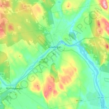
Name: Topografische Karte Skowhegan, Höhe, Relief.
Ort: Skowhegan, Somerset County, Maine, United States (44.68690 -69.75999 44.82438 -69.58099)
Durchschnittliche Höhe: 101 m
Minimale Höhe: 29 m
Maximale Höhe: 260 m
According to the United States Census Bureau, the town has a total area of 60.47 square miles (156.62 km2), of which 58.85 square miles (152.42 km2) is land and 1.62 square miles (4.20 km2) is water. Skowhegan is drained by the Wesserunsett Stream and Kennebec River. Loomis Hill, elevation 870 feet (265 meters) above sea level, is the highest point in town.
Andere topografische Karten
Klicken Sie auf eine Karte, um ihre Topografie, ihre Höhe und ihr Relief anzuzeigen.
Cornville
United States > Maine > Somerset County
Cornville, Somerset County, Maine, United States
Durchschnittliche Höhe: 115 m
Parlin Pond
United States > Maine > Somerset County > Parlin Pond Township
Parlin Pond, Parlin Pond Township, Somerset County, Maine, United States
Durchschnittliche Höhe: 529 m
Gray Island
United States > Maine > Somerset County > Solon
Gray Island, Solon, Somerset County, Maine, United States
Durchschnittliche Höhe: 105 m
Mackamp
United States > Maine > Somerset County
Mackamp, Long Pond Township, Somerset County, Maine, United States
Durchschnittliche Höhe: 395 m
West Forks Plantation
United States > Maine > Somerset County
West Forks Plantation, Somerset County, Maine, 04985, United States
Durchschnittliche Höhe: 387 m
Fairfield
United States > Maine > Somerset County
Fairfield, Somerset County, Maine, United States
Durchschnittliche Höhe: 64 m
Madison
United States > Maine > Somerset County
Madison, Somerset County, Maine, 04950, United States
Durchschnittliche Höhe: 124 m
Norris Brook
United States > Maine > Somerset County
Norris Brook, T5 R18 WELS, Somerset County, Maine, United States
Durchschnittliche Höhe: 420 m
Bigelow Hill
United States > Maine > Somerset County > Skowhegan
Bigelow Hill, Skowhegan, Somerset County, Maine, United States
Durchschnittliche Höhe: 158 m
Smithfield
United States > Maine > Somerset County > Smithfield
Smithfield, Somerset County, Maine, 04978, United States
Durchschnittliche Höhe: 105 m
Ham Hill
United States > Maine > Somerset County > Cambridge
Ham Hill, Cambridge, Somerset County, Maine, 04923, United States
Durchschnittliche Höhe: 188 m