
Topografische Karte Woodford County
Interaktive Karte
Klicken Sie auf die Karte, um die Höhe anzuzeigen.
Über diese Karte
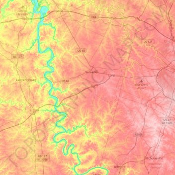
Name: Topografische Karte Woodford County, Höhe, Relief.
Ort: Woodford County, Kentucky, United States (37.84710 -84.86568 38.19543 -84.62508)
Durchschnittliche Höhe: 259 m
Minimale Höhe: 146 m
Maximale Höhe: 326 m
Andere topografische Karten
Klicken Sie auf eine Karte, um ihre Topografie, ihre Höhe und ihr Relief anzuzeigen.
Midway
United States > Kentucky > Woodford County
Midway, Woodford County, Kentucky, United States
Durchschnittliche Höhe: 256 m
Versailles
United States > Kentucky > Woodford County
Versailles, Woodford County, Kentucky, 40383, United States
Durchschnittliche Höhe: 275 m