
Topografische Karte Smithgall Woods State Park
Interaktive Karte
Klicken Sie auf die Karte, um die Höhe anzuzeigen.
Über diese Karte
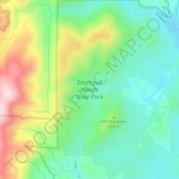
Name: Topografische Karte Smithgall Woods State Park, Höhe, Relief.
Durchschnittliche Höhe: 612 m
Minimale Höhe: 467 m
Maximale Höhe: 891 m
Andere topografische Karten
Klicken Sie auf eine Karte, um ihre Topografie, ihre Höhe und ihr Relief anzuzeigen.
Helen
United States > Georgia > White County
Helen, White County, Georgia, 30545, United States
Durchschnittliche Höhe: 488 m
Unicoi Lake
United States > Georgia > White County
Unicoi Lake, White County, Georgia, United States
Durchschnittliche Höhe: 562 m
Nacoochee
United States > Georgia > White County
Nacoochee, White County, Georgia, 30545, United States
Durchschnittliche Höhe: 449 m
Raven Cliff Falls
United States > Georgia > White County
Raven Cliff Falls, White County, Georgia, United States
Durchschnittliche Höhe: 922 m
Cleveland
United States > Georgia > White County
Cleveland, White County, Georgia, 30528, United States
Durchschnittliche Höhe: 479 m
Mossy Creek
United States > Georgia > White County
Mossy Creek, White County, Georgia, United States
Durchschnittliche Höhe: 416 m
Sautee
United States > Georgia > White County
Sautee, White County, Georgia, 30571, United States
Durchschnittliche Höhe: 441 m
Yonah Mountain
United States > Georgia > White County
Yonah Mountain, White County, Georgia, United States
Durchschnittliche Höhe: 619 m