
Topografische Karte Etna
Interaktive Karte
Klicken Sie auf die Karte, um die Höhe anzuzeigen.
Etna
Etna has a beautiful hilly topography with dramatic exposed shale rock as you enter Etna borough off of Route 28 from Pittsburgh. The downtown area is a quaint main street named one of the best main streets in Pennsylvania in 2021.
Über diese Karte
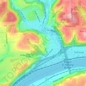
Name: Topografische Karte Etna, Höhe, Relief.
Ort: Etna, Allegheny County, Pennsylvania, United States (40.48750 -79.95828 40.50861 -79.93819)
Durchschnittliche Höhe: 274 m
Minimale Höhe: 218 m
Maximale Höhe: 360 m