
Topografische Karte Winlock
Interaktive Karte
Klicken Sie auf die Karte, um die Höhe anzuzeigen.
Über diese Karte
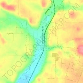
Name: Topografische Karte Winlock, Höhe, Relief.
Ort: Winlock, Lewis County, Washington, United States (46.48013 -122.95086 46.50712 -122.91892)
Durchschnittliche Höhe: 124 m
Minimale Höhe: 78 m
Maximale Höhe: 162 m
The eastern edge of the Willapa Hills lie to the west. To the east are relatively flat prairies. A notable landmark about four miles west of town is Sam Henry Mountain, elevation 1,492 feet (455 m), named for an early section superintendent of the Northern Pacific Railroad. Mt. St. Helens, about forty miles (64.4 km) to the east can be seen from viewpoints around the area. In May 1980, Winlock was covered with about one inch (2.54 cm) of volcanic ash from the second major eruption of this peak one week after the cataclysmic eruption of May 18.
Andere topografische Karten
Klicken Sie auf eine Karte, um ihre Topografie, ihre Höhe und ihr Relief anzuzeigen.
Cinebar
United States > Washington > Lewis County
Cinebar, Lewis County, Washington, 98533, United States
Durchschnittliche Höhe: 308 m
Narada Falls
United States > Washington > Lewis County
Narada Falls, Lewis County, Washington, United States
Durchschnittliche Höhe: 1.444 m
Fords Prairie
United States > Washington > Lewis County
Fords Prairie, Lewis County, Washington, United States
Durchschnittliche Höhe: 67 m
Bremer
United States > Washington > Lewis County
Bremer, Lewis County, Washington, United States
Durchschnittliche Höhe: 430 m
Walupt Creek Falls
United States > Washington > Lewis County
Walupt Creek Falls, Lewis County, Washington, United States
Durchschnittliche Höhe: 1.158 m
Centralia
United States > Washington > Lewis County
Centralia, Lewis County, Washington, United States
Durchschnittliche Höhe: 74 m
Napavine
United States > Washington > Lewis County
Napavine, Lewis County, Washington, 98565, United States
Durchschnittliche Höhe: 105 m
Adna
United States > Washington > Lewis County
Adna, Lewis County, Washington, United States
Durchschnittliche Höhe: 82 m
Chehalis
United States > Washington > Lewis County
Chehalis, Lewis County, Washington, United States
Durchschnittliche Höhe: 81 m
Chimney Rock
United States > Washington > Lewis County
Chimney Rock, Lewis County, Washington, United States
Durchschnittliche Höhe: 1.593 m
Glenoma
United States > Washington > Lewis County
Glenoma, Lewis County, Washington, 98336, United States
Durchschnittliche Höhe: 354 m
Vader
United States > Washington > Lewis County
Vader, Lewis County, Washington, 98593, United States
Durchschnittliche Höhe: 74 m
Morton
United States > Washington > Lewis County
Morton, Lewis County, Washington, United States
Durchschnittliche Höhe: 328 m
Onalaska
United States > Washington > Lewis County
Onalaska, Lewis County, Washington, 98570, United States
Durchschnittliche Höhe: 170 m
Mossyrock
United States > Washington > Lewis County > Mossyrock
Mossyrock, Lewis County, Washington, 98564, United States
Durchschnittliche Höhe: 213 m
Mineral
United States > Washington > Lewis County > Mineral
Mineral, Lewis County, Washington, 98355, United States
Durchschnittliche Höhe: 481 m
Randle
United States > Washington > Lewis County
Randle, Lewis County, Washington, United States
Durchschnittliche Höhe: 378 m
Packwood
United States > Washington > Lewis County
Packwood, Lewis County, Washington, United States
Durchschnittliche Höhe: 379 m