
Topografische Karte Dullstroom
Interaktive Karte
Klicken Sie auf die Karte, um die Höhe anzuzeigen.
Über diese Karte
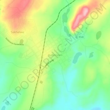
Name: Topografische Karte Dullstroom, Höhe, Relief.
Durchschnittliche Höhe: 2.009 m
Minimale Höhe: 1.939 m
Maximale Höhe: 2.112 m
Due to its high elevation (Dullstroom being the highest town in South Africa itself), Dullstroom has a subtropical highland climate (Köppen: Cwb). From October to April, the town sees a significant amount of rainfall (higher than nearby Johannesburg to the west), in contrast with winter, where precipitation lacks.
Andere topografische Karten
Klicken Sie auf eine Karte, um ihre Topografie, ihre Höhe und ihr Relief anzuzeigen.
Machadodorp
South Africa > Mpumalanga > Nkangala > Emakhazeni Local Municipality
eNtokozweni (Machadodorp), Emakhazeni Ward 6, Machadodorp, Emakhazeni Local Municipality, Nkangala, Mpumalanga, South Africa
Durchschnittliche Höhe: 1.560 m