
Topografische Karte New Limerick
Interaktive Karte
Klicken Sie auf die Karte, um die Höhe anzuzeigen.
Über diese Karte
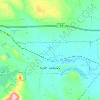
Name: Topografische Karte New Limerick, Höhe, Relief.
Ort: New Limerick, Aroostook County, Maine, 04761, United States (46.09527 -68.04059 46.14114 -67.90387)
Durchschnittliche Höhe: 155 m
Minimale Höhe: 111 m
Maximale Höhe: 370 m
Andere topografische Karten
Klicken Sie auf eine Karte, um ihre Topografie, ihre Höhe und ihr Relief anzuzeigen.
Portage
United States > Maine > Aroostook County > Portage Lake
Portage, Portage Lake, Aroostook County, Maine, 04768, United States
Durchschnittliche Höhe: 226 m
Masardis
United States > Maine > Aroostook County
Masardis, Aroostook County, Maine, United States
Durchschnittliche Höhe: 199 m
Presque Isle
United States > Maine > Aroostook County
Presque Isle, Aroostook County, Maine, 04769, United States
Durchschnittliche Höhe: 180 m
Island Falls
United States > Maine > Aroostook County
Island Falls, Aroostook County, Maine, 04747, United States
Durchschnittliche Höhe: 159 m
Frenchville
United States > Maine > Aroostook County > Frenchville
Frenchville, Aroostook County, Maine, 04745, United States
Durchschnittliche Höhe: 252 m
Little Black River
United States > Maine > Aroostook County > Allagash
Little Black River, Allagash, Aroostook County, Maine, United States
Durchschnittliche Höhe: 329 m
Saint John River
United States > Maine > Aroostook County > Fort Kent
Saint John River, Fort Kent, Aroostook County, Maine, United States
Durchschnittliche Höhe: 208 m
Houlton
United States > Maine > Aroostook County > Houlton
Houlton, Aroostook County, Maine, 04730, United States
Durchschnittliche Höhe: 133 m
Maple Mountain
United States > Maine > Aroostook County
Maple Mountain, Aroostook County, Maine, United States
Durchschnittliche Höhe: 316 m