
Spenden
Rüste dich für dein nächstes Abenteuer:
Als Amazon-Partner verdient diese Website an qualifizierten Käufen, ohne zusätzliche Kosten für Sie.
Topografische Karte DeLand
Klicken Sie auf die Karte, um die Höhe anzuzeigen.
Spenden
Rüste dich für dein nächstes Abenteuer:
Als Amazon-Partner verdient diese Website an qualifizierten Käufen, ohne zusätzliche Kosten für Sie.
Über diese Karte
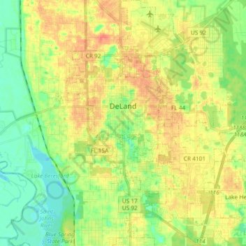
Name: Topografische Karte DeLand, Höhe, Relief.
Ort: DeLand, Volusia County, Florida, 32723, United States (28.95548 -81.34314 29.08338 -81.23535)
Durchschnittliche Höhe: 20 m
Minimale Höhe: -1 m
Maximale Höhe: 41 m
Spenden
Rüste dich für dein nächstes Abenteuer:
Als Amazon-Partner verdient diese Website an qualifizierten Käufen, ohne zusätzliche Kosten für Sie.
Andere topografische Karten
Klicken Sie auf eine Karte, um ihre Topografie, ihre Höhe und ihr Relief anzuzeigen.
Samsula-Spruce Creek
United States > Florida > Volusia County > New Smyrna Beach > South Village
Durchschnittliche Höhe: 8 m
De Leon Springs
United States > Florida > Volusia County > De Leon Springs
Durchschnittliche Höhe: 17 m
Spenden
Rüste dich für dein nächstes Abenteuer:
Als Amazon-Partner verdient diese Website an qualifizierten Käufen, ohne zusätzliche Kosten für Sie.
Spenden
Rüste dich für dein nächstes Abenteuer:
Als Amazon-Partner verdient diese Website an qualifizierten Käufen, ohne zusätzliche Kosten für Sie.
Spenden
Rüste dich für dein nächstes Abenteuer:
Als Amazon-Partner verdient diese Website an qualifizierten Käufen, ohne zusätzliche Kosten für Sie.
De Leon Springs
United States > Florida > Volusia County > De Leon Springs
Durchschnittliche Höhe: 17 m
Spenden
Rüste dich für dein nächstes Abenteuer:
Als Amazon-Partner verdient diese Website an qualifizierten Käufen, ohne zusätzliche Kosten für Sie.
Halifax Estates
United States > Florida > Volusia County > Daytona Beach Shores
Durchschnittliche Höhe: 1 m
Cypress Lake Park
United States > Florida > Volusia County > Cypress Lake Estates
Durchschnittliche Höhe: 22 m
Spenden
Rüste dich für dein nächstes Abenteuer:
Als Amazon-Partner verdient diese Website an qualifizierten Käufen, ohne zusätzliche Kosten für Sie.
De Leon Springs
United States > Florida > Volusia County > De Leon Springs
Durchschnittliche Höhe: 17 m
Spenden
Rüste dich für dein nächstes Abenteuer:
Als Amazon-Partner verdient diese Website an qualifizierten Käufen, ohne zusätzliche Kosten für Sie.
Spenden
Rüste dich für dein nächstes Abenteuer:
Als Amazon-Partner verdient diese Website an qualifizierten Käufen, ohne zusätzliche Kosten für Sie.