
Topografische Karte Pittsburgh
Interaktive Karte
Klicken Sie auf die Karte, um die Höhe anzuzeigen.
Über diese Karte
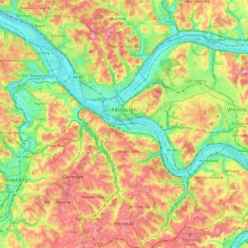
Name: Topografische Karte Pittsburgh, Höhe, Relief.
Ort: Pittsburgh, Allegheny County, Pennsylvania, United States (40.36152 -80.09552 40.50120 -79.86573)
Durchschnittliche Höhe: 303 m
Minimale Höhe: 212 m
Maximale Höhe: 413 m
The warmest month of the year in Pittsburgh is July, with a 24-hour average of 73.2 °F (22.9 °C). Conditions are often humid, and combined with highs reaching 90 °F (32 °C) on an average 9.5 days a year, a considerable heat index arises. The coolest month is January, when the 24-hour average is 28.8 °F (−1.8 °C), and lows of 0 °F (−18 °C) or below can be expected on an average 2.6 nights per year. Officially, record temperatures range from −22 °F (−30 °C), on January 19, 1994 to 103 °F (39 °C), which occurred three times, most recently on July 16, 1988; the record cold daily maximum is −3 °F (−19 °C), which occurred three times, most recently the day of the all-time record low, while, conversely, the record warm daily minimum is 82 °F (28 °C) on July 1, 1901. Due to elevation and location on the windward side of the Appalachian Mountains, 100 °F (38 °C)+ readings are very rare, and were last seen on July 15, 1995.
Andere topografische Karten
Klicken Sie auf eine Karte, um ihre Topografie, ihre Höhe und ihr Relief anzuzeigen.
Glenshaw
United States > Pennsylvania > Allegheny County > Shaler Township
Glenshaw, Shaler Township, Allegheny County, Pennsylvania, 15116, United States
Durchschnittliche Höhe: 312 m
Brackenridge
United States > Pennsylvania > Allegheny County
Brackenridge, Allegheny County, Pennsylvania, 15014, United States
Durchschnittliche Höhe: 266 m
Edgeworth
United States > Pennsylvania > Allegheny County
Edgeworth, Allegheny County, Pennsylvania, United States
Durchschnittliche Höhe: 266 m