
Topografische Karte Clifford Township
Interaktive Karte
Klicken Sie auf die Karte, um die Höhe anzuzeigen.
Über diese Karte
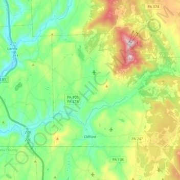
Name: Topografische Karte Clifford Township, Höhe, Relief.
Durchschnittliche Höhe: 440 m
Minimale Höhe: 255 m
Maximale Höhe: 817 m
Andere topografische Karten
Klicken Sie auf eine Karte, um ihre Topografie, ihre Höhe und ihr Relief anzuzeigen.
Lenoxville
United States > Pennsylvania > Susquehanna County
Lenoxville, Lenox Township, Susquehanna County, Pennsylvania, 18413, United States
Durchschnittliche Höhe: 380 m
New Milford
United States > Pennsylvania > Susquehanna County
New Milford, Susquehanna County, Pennsylvania, United States
Durchschnittliche Höhe: 412 m
Montrose
United States > Pennsylvania > Susquehanna County
Montrose, Susquehanna County, Pennsylvania, 18801, United States
Durchschnittliche Höhe: 489 m
Smiley
United States > Pennsylvania > Susquehanna County
Smiley, Gibson Township, Susquehanna County, Pennsylvania, 18825, United States
Durchschnittliche Höhe: 440 m
Thompson
United States > Pennsylvania > Susquehanna County
Thompson, Susquehanna County, Pennsylvania, United States
Durchschnittliche Höhe: 542 m
Forest Lake
United States > Pennsylvania > Susquehanna County > Forest Lake
Forest Lake, Susquehanna County, Pennsylvania, United States
Durchschnittliche Höhe: 497 m
Smokey Mountain
United States > Pennsylvania > Susquehanna County
Smokey Mountain, Susquehanna County, Pennsylvania, United States
Durchschnittliche Höhe: 359 m