
Topografische Karte Évora
Interaktive Karte
Klicken Sie auf die Karte, um die Höhe anzuzeigen.
Über diese Karte
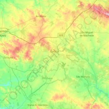
Name: Topografische Karte Évora, Höhe, Relief.
Ort: Évora, Portugal (38.34068 -8.16570 38.76820 -7.55494)
Durchschnittliche Höhe: 247 m
Minimale Höhe: 112 m
Maximale Höhe: 550 m
Évora (altitude 300m) is situated in Alentejo, a large region of wide plains in the south of Portugal, bordered to the North by the Tagus River and to the South by the region of Algarve. The city is 140 km (87 mi) from the capital city Lisbon, and 80 km (50 mi) from Badajoz at the Spanish border. It is the chief city of the region.
Andere topografische Karten
Klicken Sie auf eine Karte, um ihre Topografie, ihre Höhe und ihr Relief anzuzeigen.
Cabrela
Portugal > Évora > Montemor-o-Novo
Cabrela, Montemor-o-Novo, Évora, Portugal
Durchschnittliche Höhe: 110 m
Terena
Portugal > Évora > Terena (São Pedro)
Terena, Terena (São Pedro), Alandroal, Évora, 7250-065, Portugal
Durchschnittliche Höhe: 191 m
Reguengos de Monsaraz
Reguengos de Monsaraz, Évora, Portugal
Durchschnittliche Höhe: 207 m
Ribeira de Cabrela
Ribeira de Cabrela, Cabrela, Montemor-o-Novo, Évora, Portugal
Durchschnittliche Höhe: 76 m
Évora Monte
Portugal > Évora > Évora Monte > Évora Monte
Évora Monte, Estremoz, Évora, Portugal
Durchschnittliche Höhe: 325 m