
Topografische Karte McCollum
Interaktive Karte
Klicken Sie auf die Karte, um die Höhe anzuzeigen.
Über diese Karte
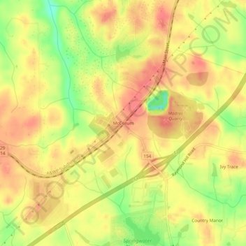
Name: Topografische Karte McCollum, Höhe, Relief.
Ort: McCollum, Coweta County, Georgia, 30265, United States (33.43039 -84.72021 33.47039 -84.68021)
Durchschnittliche Höhe: 284 m
Minimale Höhe: 238 m
Maximale Höhe: 312 m
Andere topografische Karten
Klicken Sie auf eine Karte, um ihre Topografie, ihre Höhe und ihr Relief anzuzeigen.
Newnan
United States > Georgia > Coweta County
Newnan, Coweta County, Georgia, 30263, United States
Durchschnittliche Höhe: 272 m
Turin
United States > Georgia > Coweta County
Turin, Coweta County, Georgia, 30289, United States
Durchschnittliche Höhe: 273 m
Moreland
United States > Georgia > Coweta County
Moreland, Coweta County, Georgia, United States
Durchschnittliche Höhe: 277 m
Thomas Crossroads
United States > Georgia > Coweta County
Thomas Crossroads, Coweta County, Georgia, 30277, United States
Durchschnittliche Höhe: 283 m
East Newnan
United States > Georgia > Coweta County
East Newnan, Coweta County, Georgia, 30263, United States
Durchschnittliche Höhe: 290 m
Haralson
United States > Georgia > Coweta County
Haralson, Coweta County, Georgia, 30229, United States
Durchschnittliche Höhe: 250 m
Arnco Mills
United States > Georgia > Coweta County
Arnco Mills, Coweta County, Georgia, 30275, United States
Durchschnittliche Höhe: 256 m
McBride
United States > Georgia > Coweta County > Newnan
McBride, Newnan, Coweta County, Georgia, 30263, United States
Durchschnittliche Höhe: 280 m
Grantville
United States > Georgia > Coweta County
Grantville, Coweta County, Georgia, United States
Durchschnittliche Höhe: 245 m
Sharpsburg
United States > Georgia > Coweta County
Sharpsburg, Coweta County, Georgia, United States
Durchschnittliche Höhe: 273 m
Senoia
United States > Georgia > Coweta County
Senoia, Coweta County, Georgia, United States
Durchschnittliche Höhe: 248 m