
Topografische Karte Horseleap
Interaktive Karte
Klicken Sie auf die Karte, um die Höhe anzuzeigen.
Über diese Karte
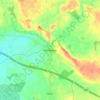
Name: Topografische Karte Horseleap, Höhe, Relief.
Durchschnittliche Höhe: 70 m
Minimale Höhe: 50 m
Maximale Höhe: 94 m
Andere topografische Karten
Klicken Sie auf eine Karte, um ihre Topografie, ihre Höhe und ihr Relief anzuzeigen.
Clara
Clara, Clara ED, The Municipal District of Tullamore, County Offaly, Leinster, Ireland
Durchschnittliche Höhe: 62 m
The Municipal District of Birr
The Municipal District of Birr, County Offaly, Leinster, Ireland
Durchschnittliche Höhe: 97 m
Wood
Wood, Ballyburly ED, The Municipal District of Edenderry, County Offaly, Leinster, Ireland
Durchschnittliche Höhe: 75 m
Shane Valley
Shane Valley, Edenderry Rural ED, The Municipal District of Edenderry, County Offaly, Leinster, R45 X951, Ireland
Durchschnittliche Höhe: 71 m
Down
Down, Mountbriscoe ED, The Municipal District of Edenderry, County Offaly, Leinster, Ireland
Durchschnittliche Höhe: 88 m